Research Highlights
My research is focused on modelling and observing the flow of ice and water in ice sheets and glaciers.
Subglacial hydrology
During my PhD I studied the flow of water beneath glaciers and ice sheets through the development and analysis of mathematical models. I studied how ice-dammed lakes fill and drain beneath glaciers, showing how simple models can be used to predict approximately when lakes will drain, lakes can fill and drain chaotically and lakes affect the flow of glaciers through their impact on subglacial water pressures.
The Nye Attractor. This anaglyph, viewable with 3D glasses, shows the chaotic behavior of a model glacial lake. This is a section of an infinitely long curve called an attractor. It shows the evolution of a model glacial lake as it fills and drains, chaotically. The curve's distance along the vertical black axis is the flow out of the lake, its distance from the axis is the lake's depth and its rotation round the axis is time. It is named for the British glaciologist John Nye who devised the model in 1976. This anaglyph is designed to be viewed with 3D glasses. Kingslake, J. Chaotic dynamics of a glaciohydraulic model. J Glac. (61)227.
Glacier geophysics
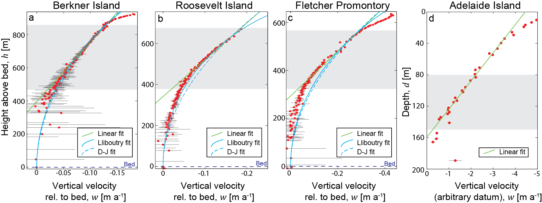
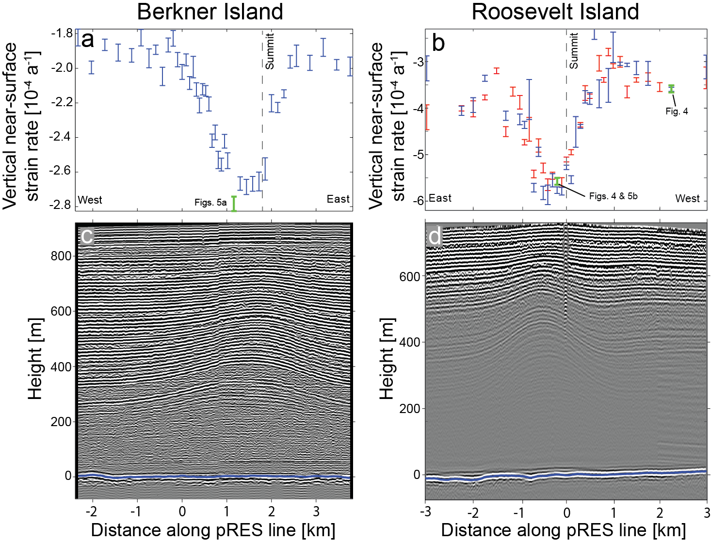
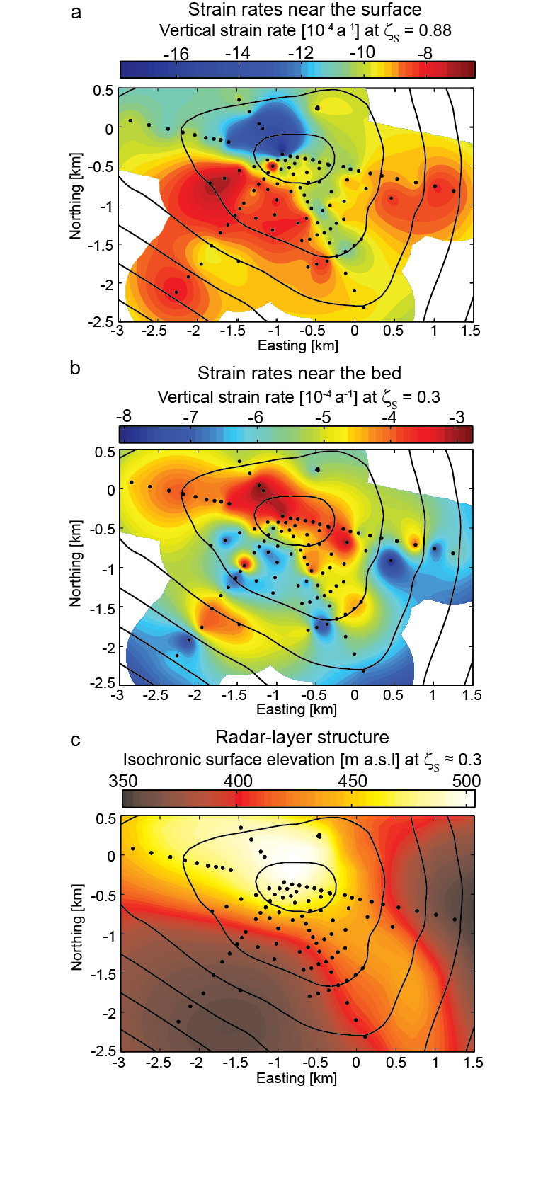
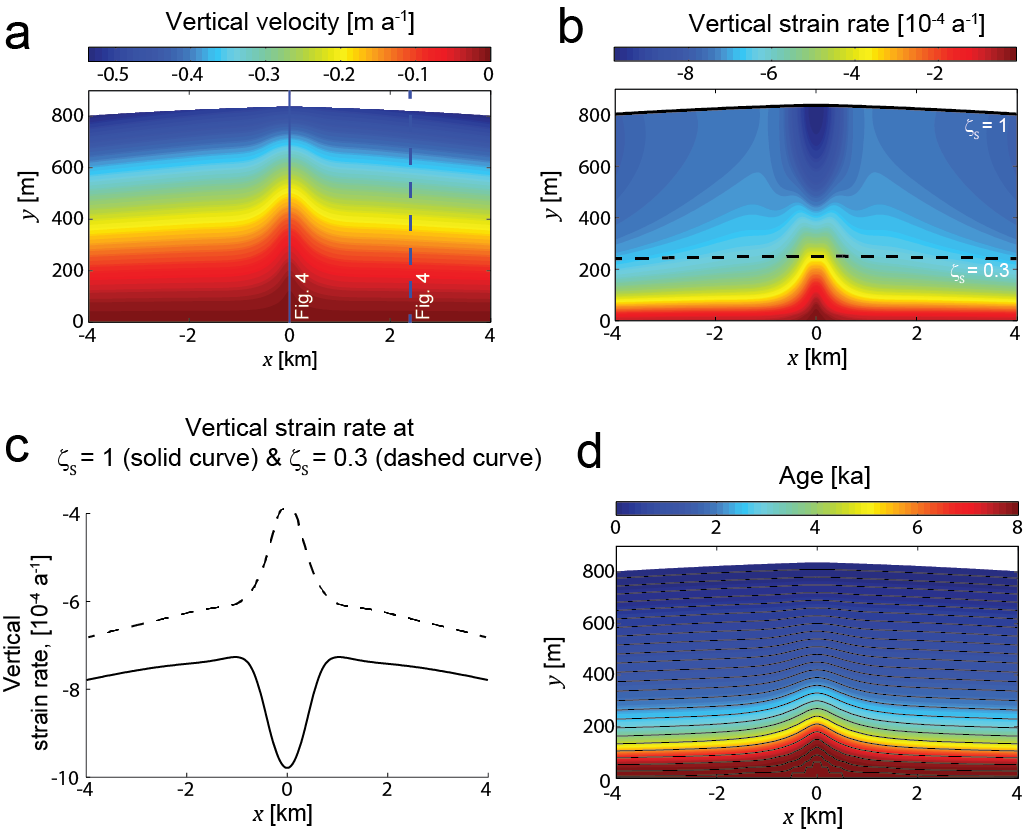
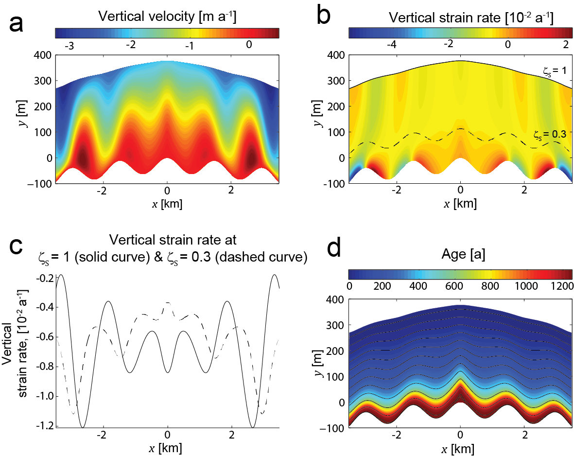
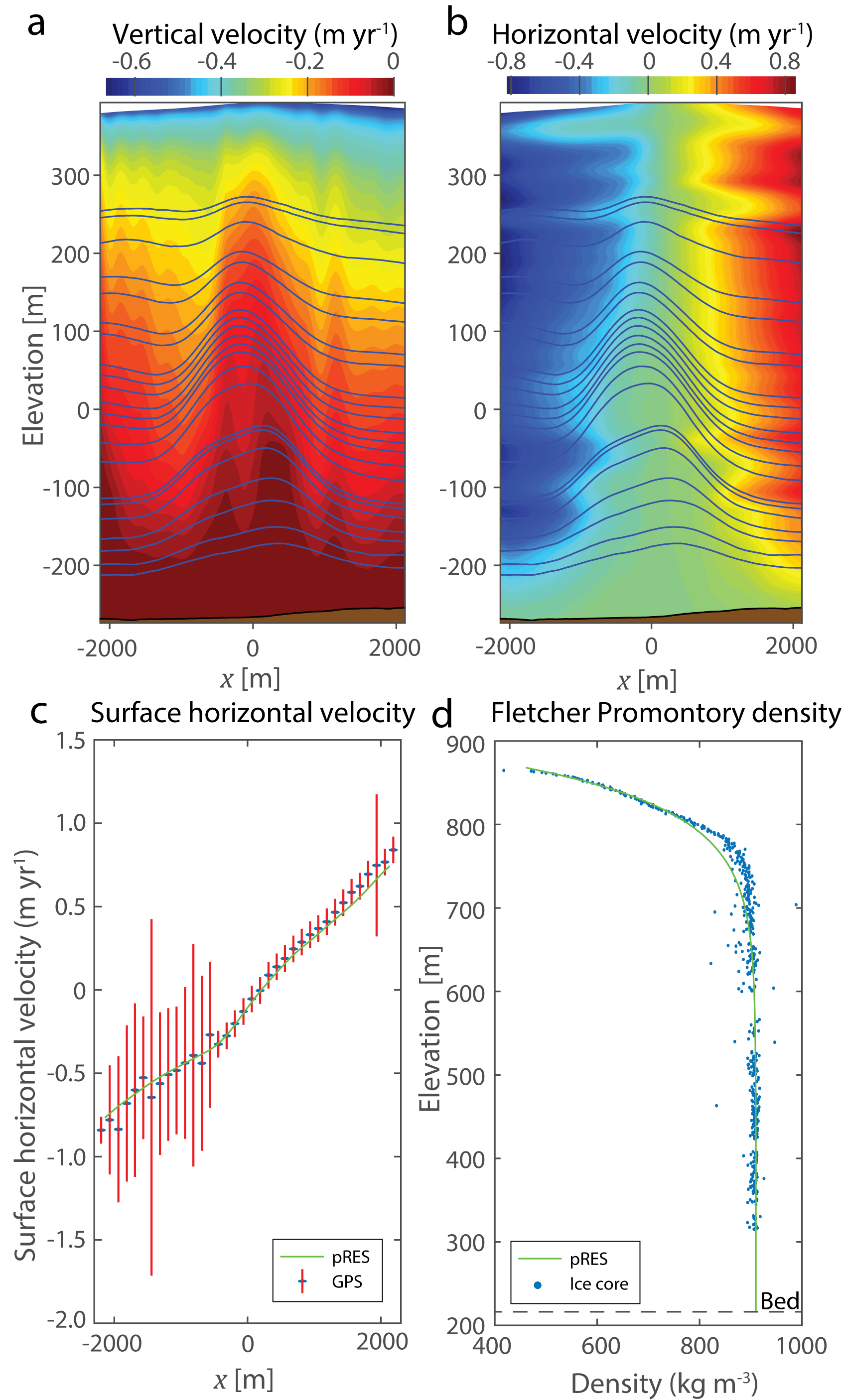
My work at the British Antarctic Survey focused on using radar to constrain present and past ice flow in the Ronne Ice Shelf region of West Antarctica. We used a phase-sensitive radar system to measure an ice-dynamical phenomenon called the Raymond Effect.
We have used data from this radar to measure englacial ice flow and help to determine the history of ice flow in Antarctica (here)
Elizabeth Case subsequently used similar data to measure the compaction of snow (and “firn”) into glacial ice (published here), and we are using a newer version of the same radar to measure deformation around supraglacial lakes in Greenland as part of this NSF-funded project.


Ice-sheet history
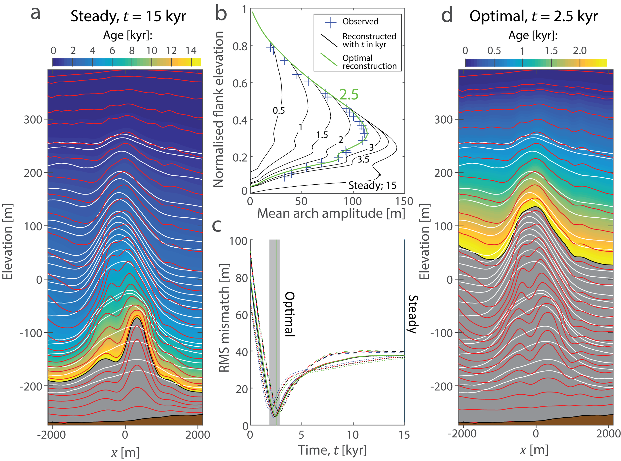
In 2018 I co-led a paper presenting evidence that the West Antarctic Ice Sheet was smaller than it is today during the Holocene, in both the Weddell Sea and Ross Sea sectors. This work was done as part of a team of 10 scientists from 5 institutions across 3 countries. We hypothesized that readvance was caused by the delayed response of the lithosphere to unloading following the Last Glacial Maximum. The evidence for this came from ice-penetrating radar and radiocarbon found in subglacial sediments, and we examined the implications of and controls on the readvance using a continent-wide ice-sheet model. The image below comes from the paper. It shows maximum and minimum grounding line positions predicted by the model.

In a paper from 2016, we used phase-sensitive radar and GPS to infer vertical and horizontal ice flow fields throughout the thickness of Korff Ice Rise, West Antarctica. We used these englacial flow fields with radar observations of internal layers within the ice rise to show that the flow of his part of the ice sheet underwent a reorganization around 2-3 kyr ago. Continued research into the history of the West Antarctic Ice Sheet is bringing together geophysical and sedimentological data with ice-sheet modelling, to understand large-scale change during the last few thousand years.

Supraglacial hydrology
Though my PhD work was focused on lakes that drain subglacially (beneath glaciers and ice sheets), I was also interested in surface melt ponds and how they drain supraglacially (across the surface of the ice). Both subglacial and supraglacial drainage can involve flow paths that grow due to frictional melting from the flowing water, so some aspects of these two types of drainage are similar. I modeled the physics of supraglacial drainage, finding that melt ponds can drain stably or unstably over the surface of the ice. Which style of drainage occurs depends on factors like the size and shape of ponds and the input to the lake from its catchment. This is potentially significant because these factors may vary systematically as the climate changes, and drainage style fundamentally impacts the amount of water that is drained towards the ocean. This work is published here.
At Lamont I have been able to revisit supraglacial hydrology. Throughout 2016 I, along with Lamont colleagues, explored the supraglacial hydrology (i.e. hydrology that goes on on the surface of ice) of Antarctica. This has been exciting because only a few previous studies have looked at water moving across the surface of Antarctica, but we concluded that surface water flow potentially has an important role to play in the future of the Antarctic Ice Sheet.
In two papers (here and here) recently published in Nature, and summarized in the same issue (here), we showed that water has been moving long distances onto and across many Antarctic Ice Shelves for many decades (possibly much longer).
Our research is now focused on understanding how these drainage systems operate and how they develop under changing environmental conditions. Julian Spergel, a PhD candidate in the Earth and Environmental Sciences department here at Columbia, is leading this work. Julian’s first paper in the topic is published in the Journal of Glaciology (here).

This animation shows a series of images taken by NASA's LANDSAT7 satellite. Over a period of around 3 1/2 weeks this large pond on Amery Ice Shelf, East Antarctica, inundated an area of 55 square kilometers.
These observations of widespread supraglacial hydrology in Antarctica are interesting because as the continent warms, water could either move into areas where it can cause ice shelves to collapse, or it could evacuate water into the oceans as shown by one of our papers. The movie below, taken from a helicopter, shows a large water fall at the front of the Nansen Ice Shelf.